Exploring Northumberland's Rock Art
by Teri Foster Gray
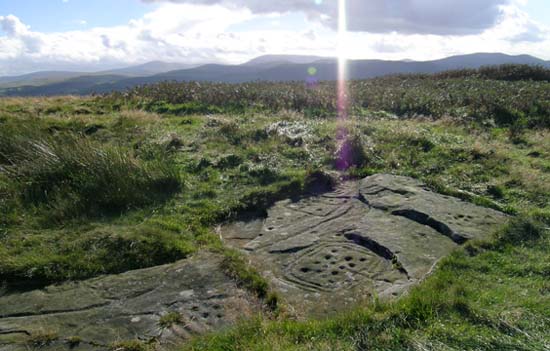
 We climb a sheep-dotted hillside, past bluebells and
dandelions, our destination a gray boulder indistinguishable at a
distance from the dozen or so others in view. A closer
inspection, however, reveals why this rock is worth a 3000 mile
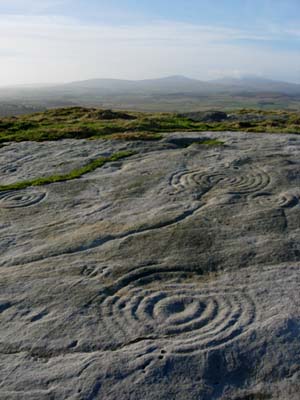
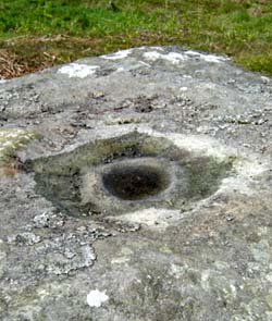
journey, plus a stiff walk up the hill. On it, carved half an
inch or so deep, is a cup-like hole, surrounded by a series of
concentric rings, carved, it is believed, between 5000 and 7000
years ago by members of a Mesolithic hunter-gatherer culture, or
perhaps early Neolithic farmers. We climb a sheep-dotted hillside, past bluebells and
dandelions, our destination a gray boulder indistinguishable at a
distance from the dozen or so others in view. A closer
inspection, however, reveals why this rock is worth a 3000 mile
journey, plus a stiff walk up the hill. On it, carved half an
inch or so deep, is a cup-like hole, surrounded by a series of
concentric rings, carved, it is believed, between 5000 and 7000
years ago by members of a Mesolithic hunter-gatherer culture, or
perhaps early Neolithic farmers.
"We don't know for certain. We can only date these carvings
by looking at the context in which they occur and comparing them
to other known sites." Tertia Barnett is coordinator for the
Northumberland and Durham Rock Art Project, funded by a two-year
grant from English Heritage.
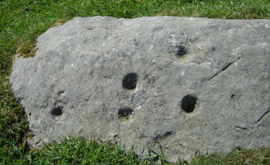
Although Rock Art has been a part of the English landscape for
nearly as long as England has been inhabited, and the first
specimens were collected nearly two centuries ago by
archaeologists under the patronage of Algernon, 4th Duke of
Northumbria, it has only attracted serious academic attention
within the last 30 years. Unlike the higher profile henges and
burial markers, these carvings literally blend into the
landscape. (One piece was found underneath when a farmer moved
the winter feeding station for his cattle.)
"Everyone working on the project," which includes 80
volunteers from local communities, "has their own theory --
religious symbols, territorial markings, burial markers, Ley
lines, trail markers," says Tertia. "Carvings have been
found in locations that could allow us to use any of these
interpretations, and many more." Fifty of the volunteers
have been trained in field recording and survey techniques; the
remainder work at data entry and other, more sedentary, tasks.
The carvings extend from the south Durham area through
Northumberland and Cumbria, into Scotland and as far west as the
Isle of Man. They occur at elevations where the local gray
sandstone appears as outcrops. Northumberland is the
best-documented region, due in great part to the efforts of Dr. Stan Beckensall, an expert in prehistoric rock art.
In December of 2002, Mr. Beckinsall donated his collection of
photographs and documentation of more than 600 sites to the
Museum of Antiquities at Newcastle University, so that they could
be posted to the Internet and everyone could learn about British
Rock Art. So far they have succeeded brilliantly. The resulting
site received 2 million hits in its first week. The Project's
first goal was to identify and catalog these sites and create the
website. Future projects will build on this one. As the database
grows, it will become possible to compare the design grammar of
various sites and try to determine the relationships among them.
It will also be possible to work out the relationship of the
carved rocks to the natural landscape and to other archaeological
features.
Tertia leads us over the hilltop to the concentric ruins of an
Iron Age fort that overlooks miles of northwest-facing valley.
Two RAF fighter jets thunder overhead -- fitting, in a strange
way -- as cutting-edge technology now may find answers to the
questions, "Who made them?" and "For what
purpose?" "The Mesolithic is really a very fascinating
period, and one that we only recently have begun to pay attention
to. The remains are very subtle and easily destroyed. It's only
recently, due to modern technology, that we have we been able to
pick up data from the Mesolithic and begun to realize that it's
such an important time." Make no mistake -- viewing rock art
is not for the couch potato. Stone is the most common building
material in this part of England and the more easily accessible
specimens disappeared long ago into fences, houses, churches,
castles, and outbuildings. Most sites are on private land and a
pre-visit phone call to the farmer is expected. (And, no, he is
not expected to show you about.) Other essential equipment
includes an Ordnance Map, GPS device, and footwear compatible
with mud. Prehistoric Rock Art is not tourist-friendly.
 The Project hopes to
change that when it teams with the Beckinsall Archive to post
photos drawings and access information (including farmers' phone
numbers) on the Web. In addition, by the end of the grant's term
in September 2006, Tertia hopes to determine the two or three
best sites for public viewing, clear trails, and create flyers
for distribution at local Tourist Information Centers.
"Best" will be determined by a combination of factors
including land ownership, proximity to established hiking trails,
and the quality of the site. "We don't plan to have
buildings with car parks and dioramas. We want to keep the art
within its context as part of the landscape," says Tertia.
The next phase of the project will bring the carvings within the
reach of even the most house-bound. Laser scanning, remote
sensing, and photogrammetry will provide 3-dimensional recordings
of selected sites that will be publicly accessible on the Web.
"You will be able to turn them round, zoom in, and change
the direction of the lighting," using existing computer
technology. In addition, exhibits are planned for the Newcastle
Museum of Antiquities within two years. The Project hopes to
change that when it teams with the Beckinsall Archive to post
photos drawings and access information (including farmers' phone
numbers) on the Web. In addition, by the end of the grant's term
in September 2006, Tertia hopes to determine the two or three
best sites for public viewing, clear trails, and create flyers
for distribution at local Tourist Information Centers.
"Best" will be determined by a combination of factors
including land ownership, proximity to established hiking trails,
and the quality of the site. "We don't plan to have
buildings with car parks and dioramas. We want to keep the art
within its context as part of the landscape," says Tertia.
The next phase of the project will bring the carvings within the
reach of even the most house-bound. Laser scanning, remote
sensing, and photogrammetry will provide 3-dimensional recordings
of selected sites that will be publicly accessible on the Web.
"You will be able to turn them round, zoom in, and change
the direction of the lighting," using existing computer
technology. In addition, exhibits are planned for the Newcastle
Museum of Antiquities within two years.
Currently, the site allows you to search by panel type, location,
map, art motif, and wheelchair accessibility, among other
criteria. The Location search includes both those on-site and
those collected in museums with full descriptions, photographs,
and access information, including GPS coordinates and, where
necessary, the phone number of the landowner. For an example of
the completeness of this information, click on the link to the
Hare Law Crags, below.
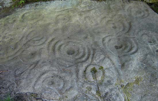
Back on the hilltop, Tertia leads us to a flat rock surface in
the center of the fort. She points out several sets of
cup-and-ring design with serpentine lines emanating from them.
Others have several short rays, like a child's depiction of the
sun. Some of them have been incised with straight lines, in
theory drawn centuries later -- this revealed by their relative
crispness and lack of erosion. These designs, along with spirals,
are the most common rock art patterns. Was the hill fort placed
here because of the carvings, or in spite of them? Did the new
residents carve the straight lines in an effort to deface the
originals, perhaps in order to destroy their magic, or to
indicate that this land no longer belonged to those who had
marked it as theirs? Was there a change over the time the hill
fort was occupied, and symbols originally perceived as powerful
and desirable became regarded as evil? No one knows.
"The transition between Mesolithic hunter-gatherers and
Neolithic farming is a fascinating time, and one which we have
only begun to study," says Tertia. "The Mesolithic
people initially moved northward as the Ice Age glaciers
receded. Recent finds demonstrate that they were more
sophisticated than previously imagined." Although they did
not farm, they built stone houses, with beaten earth or
occasionally irregular flagstone floors, the oldest in Britain
dating to 8000 BCE. Artifacts, such as flint arrowheads and spear
points reveal craftsmanship beyond the level of utility and
entering the realm of art. The shift from Meso- to Neolithic
culture is considered to have begun approximately 5000 BCE.
"Actually, the boundary between the Mesolithic and Neolithic
is not well-defined," says Tertia. Evidence shows that the
move to farming came earlier in the South and worked its way
northward, but its impetus is not clear. Did the deer become
over-hunted? Were natural food sources, fruits and the like,
over-harvested? Did the successful Mesolithic lifestyle carry the
seeds of its own destruction in the form of overpopulation, or
did the farmers and herdsmen migrate from elsewhere, pushing the
older culture back as they cut the forests for farmland and
grazing? (Incredibly, sheep are not native to Britain.)
Part of the impetus may have been the acceptance of the concept
of private property, which underlies agriculture (as opposed to
gathering) and animal husbandry (as opposed to hunting.) In
addition, as metalworking skills developed, the use of stone as
an artistic medium declined in favor of the more portable -- and
tradable -- metal goods. During the later portion of the
Mesolithic, one also sees the beginning of trading networks and
social hierarchies based upon wealth and power. "By the Iron
Age [ca. 800 BCE onward] people were very much into shiny,
glittering objects," according to Tertia. "We also see
an emphasis on ritual that the earlier periods seem to have
lacked." She leads us down the hillside, toward Scotland.
The Cheviots stand sentinel in the distance. We descend the
slope, angling downward toward an outcropping protruding from the
hillside. Another flat surface lies beneath the outcrop,
sheltered from wind and rain, and entirely covered in spirals.
She points to faint staining at the base of the outcrop.
"There may have been a spring here, and we know that springs
were worshiped in early cultures. If water seeped across this
rock, the carvings would have channeled it into spirals." Is
this the roots of religion? Magic? A good scientist, she replies,
"We don't know."
At this date, that is the definitive answer to most questions
regarding the Mesolithic in general and Rock Art in particular.
As more data accumulates and the carvings are analyzed, they will
become part of a great archaeological jigsaw puzzle that may
provide a window into the deepest roots of British civilization.
More Information:
We regret that we no longer have the resources to maintain up-to-date links and/or hours and pricing details for the various sites and attractions listed on this website. For more information about the location(s) listed above, please use your favorite search engine or visit Wikipedia.
Teri Foster Gray lives in the Pacific Northwest with her husband and Labrador Retriever. A mild-mannered banker by day, she writes novels and travels whenever possible. Her journeys have included two years in Hawaii, six months in Europe, and the British visit that resulted in this piece. She has recently completed a novel, The Shadow Empire.
Article © 2006 Teri Foster Gray
Top and bottom photos by Tertia Barnett; all other photos by Teri Foster Gray
|